![](/images/other/stat-length.png)
![Trail Walking Gemeinde Lech - Boucle Spulersee à décrire - Photo](https://media.geolcdn.com/t/1900/400/3cba9b5b-00f5-4f96-906e-5864d7078ca4.jpg&format=pjpeg&maxdim=2)
Boucle Spulersee à décrire
dboon
User
![Length](/images/other/stat-length.png)
Length
17.4 km
![Max alt](https://static1.geolcdn.com/siteimages/upload/files/1508320355ic_sort_altitude_max_24dp.png)
Max alt
2014 m
![Uphill gradient](https://static1.geolcdn.com/siteimages/upload/files/1508320355ic_sort_den_pos_24dp.png)
Uphill gradient
877 m
![Km-Effort](/images/other/stat-length.png)
Km-Effort
29 km
![Min alt](https://static1.geolcdn.com/siteimages/upload/files/1508320355ic_sort_altitude_min_24dp.png)
Min alt
1486 m
![Downhill gradient](https://static1.geolcdn.com/siteimages/upload/files/1508320355ic_sort_den_neg_24dp.png)
Downhill gradient
876 m
![Boucle](https://static1.geolcdn.com/siteimages/upload/files/16400158638029165_repeat_loop_refresh_sync_direction_icon.png)
Boucle
Yes
Creation date :
2023-06-26 06:34:47.0
Updated on :
2023-06-26 16:01:35.432
![Walking](https://static1.geolcdn.com/sitytour/trail-icons/101.png)
6h18
Difficulty : Difficult
![Scan this QR Code to open this trail in the SityTrail application](https://capi.geolives.com/qq0zvz2zws4bq2lad0pu/sitytour/trails/3713332/qr.png?size=200)
FREE GPS app for hiking
About
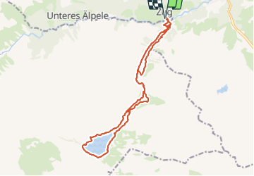
Trail Walking of 17.4 km to be discovered at Vorarlberg, Bezirk Bludenz, Gemeinde Lech. This trail is proposed by dboon.
Description
Belle boucle incluant un passage à la "Ravensburger Hütte" où nous avons fait notre pause déjeuner. En faisant cette rando, vous aurez plusieurs alternatives, dont celle de n'en faire que la moitié et de rentrer en bus à Zug (Il y a un bus toutes les heures sauf entre midi, jusqu'à 17H).
Positioning
Country:
Austria
Region :
Vorarlberg
Department/Province :
Bezirk Bludenz
Municipality :
Gemeinde Lech
Location:
Unknown
Start:(Dec)
Start:(UTM)
584092 ; 5227876 (32T) N.
Comments
Trails nearby
![Trail Walking Gemeinde Lech - Boucle à décrire - Photo](https://media.geolcdn.com/t/375/260/71aa01d9-bd8a-4619-a2cb-453691a89144.jpg&format=jpg&maxdim=2)
![Walking Walking](https://static1.geolcdn.com/sitytour/trail-icons/101.png)
Boucle à décrire
Walking
Easy
Gemeinde Lech,
Vorarlberg,
Bezirk Bludenz,
Austria
![](/images/other/stat-length.png)
8.2 km | 12 km-effort
4h 2min
![](https://static1.geolcdn.com/siteimages/upload/files/16400158638029165_repeat_loop_refresh_sync_direction_icon.png)
No
![Trail Walking Gemeinde Lech - walser_34 - Photo](https://media.geolcdn.com/t/375/260/ext.jpg?maxdim=2&url=https%3A%2F%2Fstatic1.geolcdn.com%2Fsiteimages%2Fupload%2Ffiles%2F1553511878bg_sport_marche.png)
![Walking Walking](https://static1.geolcdn.com/sitytour/trail-icons/101.png)
walser_34
Walking
Very easy
Gemeinde Lech,
Vorarlberg,
Bezirk Bludenz,
Austria
![](/images/other/stat-length.png)
10.4 km | 21 km-effort
Unknown
![](https://static1.geolcdn.com/siteimages/upload/files/16400158638029165_repeat_loop_refresh_sync_direction_icon.png)
No
![Trail Walking Gemeinde Lech - A décrire départ bus Warth - Photo](https://media.geolcdn.com/t/375/260/ext.jpg?maxdim=2&url=https%3A%2F%2Fstatic1.geolcdn.com%2Fsiteimages%2Fupload%2Ffiles%2F1553511878bg_sport_marche.png)
![Walking Walking](https://static1.geolcdn.com/sitytour/trail-icons/101.png)
A décrire départ bus Warth
Walking
Difficult
Gemeinde Lech,
Vorarlberg,
Bezirk Bludenz,
Austria
![](/images/other/stat-length.png)
14.5 km | 25 km-effort
5h 34min
![](https://static1.geolcdn.com/siteimages/upload/files/16400158638029165_repeat_loop_refresh_sync_direction_icon.png)
No